


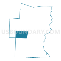
Dover Voting District, Windham County, Vermont
About
Outline

Summary
| Unique Area Identifier | 680935 |
| Name | Dover Voting District |
| County | Windham County |
| State | Vermont |
| Area (square miles) | 35.33 |
| Land Area (square miles) | 35.24 |
| Water Area (square miles) | 0.09 |
| % of Land Area | 99.75 |
| % of Water Area | 0.25 |
| Latitude of the Internal Point | 42.96548960 |
| Longtitude of the Internal Point | -72.84710740 |
Maps

Graphs
Select a template below for downloading or customizing gragh for Dover Voting District, Windham County, Vermont


Neighbors
Neighoring Voting District (by Name) Neighboring Voting District on the Map
- Marlboro Voting District, Windham County, VT
- Newfane Voting District, Windham County, VT
- Searsburg Voting District, Bennington County, VT
- Somerset Voting District, Windham County, VT
- Stratton Voting District, Windham County, VT
- Wardsboro Voting District, Windham County, VT
- Wilmington Voting District, Windham County, VT
Top 10 Neighboring County Subdivision (by Population) Neighboring County Subdivision on the Map
- Wilmington town, Windham County, VT (1,876)
- Newfane town, Windham County, VT (1,726)
- Dover town, Windham County, VT (1,124)
- Marlboro town, Windham County, VT (1,078)
- Wardsboro town, Windham County, VT (900)
- Stratton town, Windham County, VT (216)
- Searsburg town, Bennington County, VT (109)
- Somerset town, Windham County, VT (3)
Top 10 Neighboring Elementary School District (by Population) Neighboring Elementary School District on the Map
- Wilmington School District, VT (1,876)
- Newfane School District, VT (1,726)
- Dover School District, VT (1,124)
- Marlboro School District, VT (1,078)
- Wardsboro School District, VT (900)
Top 10 Neighboring Secondary School District (by Population) Neighboring Secondary School District on the Map
- Leland and Gray Union High School District 34, VT (4,942)
- Whitingham/Wilmington Joint Contract School District, VT (3,233)
Top 10 Neighboring Unified School District (by Population) Neighboring Unified School District on the Map
- Stratton School District, VT (216)
- Searsburg School District, VT (109)
- Somerset School District, VT (3)
Top 10 Neighboring State Legislative District Lower Chamber (by Population) Neighboring State Legislative District Lower Chamber on the Map
- Windham-Bennington-Windsor State House District, VT (4,355)
- Windham-6 State House District, VT (4,036)
- Windham-2 State House District, VT (3,961)
- Windham-Bennington-1 State House District, VT (3,723)
Top 10 Neighboring State Legislative District Upper Chamber (by Population) Neighboring State Legislative District Upper Chamber on the Map
Top 10 Neighboring 111th Congressional District (by Population) Neighboring 111th Congressional District on the Map
Top 10 Neighboring Census Tract (by Population) Neighboring Census Tract on the Map
- Census Tract 9706, Bennington County, VT (3,084)
- Census Tract 9680, Windham County, VT (1,876)
- Census Tract 9682, Windham County, VT (1,806)
- Census Tract 9678, Windham County, VT (1,726)
- Census Tract 9679, Windham County, VT (1,124)
- Census Tract 9675, Windham County, VT (1,119)
Top 10 Neighboring 5-Digit ZIP Code Tabulation Area (by Population) Neighboring 5-Digit ZIP Code Tabulation Area on the Map
- 05301, VT (16,820)
- 05345, VT (2,119)
- 05363, VT (2,021)
- 05355, VT (813)
- 05356, VT (717)
- 05341, VT (407)
- 05360, VT (251)